What is the NISAR Mission?

The NISAR mission is a joint project between the United States' space agency NASA (National Aeronautics and Space Administration) and India's space agency ISRO (Indian Space Research Organisation). The full form of NISAR is NASA-ISRO Synthetic Aperture Radar.
This satellite mission will map the entire Earth and monitor ongoing geographical changes by recording data twice every 12 days. It will gather crucial data related to:
- Ice sheets and glaciers on Earth's surface,
- Terrestrial ecosystem changes,
- Sea level variations, and
- Groundwater changes.
Key Agreement Highlights
- On 30th September 2014, NASA Administrator Charles Bolden and then-ISRO Chairman K. Radhakrishnan signed the agreement on the NISAR mission.
- NISAR is the first joint collaboration between NASA and ISRO on space hardware for Earth observation.
- It will be a Low Earth Orbit (LEO) satellite.
Technology and Components
- The satellite will use Synthetic Aperture Radar (SAR) technology, which enables high-resolution imaging using radar systems. The radar must move in a straight line to create such images—this function will be performed by the NISAR satellite.
- Initially planned for launch in early 2024, the mission has faced delays due to technical challenges in satellite construction.
🇺🇸 NASA's Contributions
NASA is providing:
- L-band Synthetic Aperture Radar (SAR),
- GPS receiver,
- Data communication system for scientific information,
- High-capacity solid-state recorder (acts as the satellite's hard drive), and
- Payload data sub-system.
ISRO's Contributions
ISRO is responsible for:
- S-band SAR radar,
- Launching the satellite into orbit using the GSLV Mark II rocket, and
- Satellite integration at Satish Dhawan Space Centre, Sriharikota, India.
Mission Objectives
The NISAR mission aims to study three major Earth system changes:
- Ecosystem dynamics,
- Carbon cycle shifts, and
- Earth’s surface deformations.
It will also help monitor:
- Sea level rise,
- Melting glaciers,
- Changes in carbon storage, and
- Bathymetric surveys (underwater depth mapping).
Additionally, it will be useful in studying and responding to natural disasters such as:
- Earthquakes,
- Tsunamis, and
- Volcanic eruptions.
Researchers worldwide will benefit from the precise data about even the smallest changes on Earth's surface.
Launch & Operations
- The satellite will be launched from Satish Dhawan Space Centre, Sriharikota using a GSLV Mark II rocket.
- After launch, the satellite will be positioned in orbit within the first 90 days, followed by activation of its systems.
- The mission is expected to carry out various studies for the next three years.
Prelims MCQs
1. With reference to the NISAR mission, consider the following statements: (List Type - 1)
- It is the first satellite mission jointly developed by NASA and ISRO for Earth observation.
- It will use optical imaging technology to map Earth’s surface changes.
Which of the statements given above is/are correct?
(a) 1 only
(b) 2 only
(c) Both 1 and 2
(d) Neither 1 nor 2
Answer: (a) 1 only
Explanation: NISAR is the first joint Earth observation satellite by NASA and ISRO, but it uses Synthetic Aperture Radar (SAR), not optical imaging.
2. What is the primary technology used in the NISAR mission? (Simple Type)
(a) Hyperspectral Imager
(b) Synthetic Aperture Radar
(c) Infrared Spectrometer
(d) Optical Remote Sensor
Answer: (b) Synthetic Aperture Radar
Explanation: NISAR uses L-band and S-band Synthetic Aperture Radar (SAR) to obtain high-resolution Earth surface data.
3. Match List-I with List-II and select the correct answer: (List Type - 2)
|
List-I (Component)
|
List-II (Agency Responsible)
|
|
A. L-band SAR
|
1. NASA
|
|
B. S-band SAR
|
2. ISRO
|
|
C. GSLV Mk-II Launch
|
3. ISRO
|
|
D. Solid State Recorder
|
4. NASA
|
Options:
(a) A-1; B-2; C-3; D-4
(b) A-2; B-1; C-3; D-4
(c) A-1; B-2; C-4; D-3
(d) A-2; B-1; C-4; D-3
Answer: (a) A-1; B-2; C-3; D-4
Explanation: NASA provides L-band SAR, Solid State Recorder; ISRO provides S-band SAR and GSLV Mk-II launcher.
4. Assertion (A): NISAR will help in disaster management and climate change analysis.
Reason (R): It can map Earth’s surface changes with high resolution using SAR every 12 days.
(a) Both A and R are true and R is the correct explanation of A
(b) Both A and R are true but R is not the correct explanation of A
(c) A is true but R is false
(d) A is false but R is true
Answer: (a) Both A and R are true and R is the correct explanation of A
Explanation: Frequent high-resolution radar imaging helps in detecting subtle Earth changes useful in climate monitoring and disaster response.
5. Which of the following objectives is/are part of the NISAR mission? (List Type - 1)
- Monitoring biomass and agriculture.
- Mapping lunar surface and minerals.
- Studying earthquakes and tsunamis.
Select the correct answer using the code below:
(a) 1 and 2 only
(b) 1 and 3 only
(c) 2 and 3 only
(d) 1, 2 and 3
Answer: (b) 1 and 3 only
Explanation: NISAR is not designed for lunar studies; it is for Earth observation, including biomass monitoring and disaster assessment.
UPSC Mains model questions and answers on the NISAR Mission:
Q1. What is the NISAR Mission? What are the roles of NASA and ISRO in it? How can this mission prove beneficial at both national and global levels?
Model Answer:
The NISAR (NASA-ISRO Synthetic Aperture Radar) mission is the first joint satellite mission between the United States' NASA and India's ISRO, aimed at monitoring changes on the Earth's surface, climate impacts, natural disasters, and ecosystem variations.
🔸 Role of NASA:
- L-band SAR radar
- GPS receiver
- Solid-State Recorder
- Payload communication systems
🔸 Role of ISRO:
- S-band SAR radar
- GSLV Mk-II launcher
- Satellite construction and launch
🔸 Benefits:
- Early warning of disasters like earthquakes, tsunamis, and volcanic eruptions
- Monitoring of agriculture and forest resources
- Analysis of climate change impacts
- High-quality data for the global scientific community
This mission is strategically important for India and will also prove useful in addressing global challenges related to climate change.
Q2. Why is the NISAR Mission considered a revolutionary step in Earth observation? Highlight its potential applications.
Model Answer:
The NISAR mission is considered revolutionary in Earth observation because it uses dual SAR technology (L-band and S-band) to provide high-resolution, time-bound images, enabling detection of even minute changes on the Earth's surface.
🔹 Key Applications:
- Disaster Management: Monitoring of earthquakes, landslides, floods, etc.
- Agriculture: Identification of crop areas, early detection of diseases
- Water Resources: Monitoring of groundwater levels
- Climate Change: Melting of glaciers, rise in sea level
- Forestry and Biomass: Assessment of carbon stock
Its ability to deliver data twice every 12 days enhances the accuracy of scientific analysis, thereby enabling better policy decisions.
Topic Related Videos ⬇️

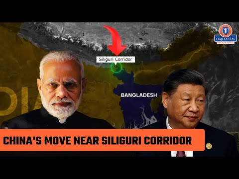
Strategic Concern: China's Involvement in Reviving Bangladesh's Lalmonirhat Airbase Near the Siliguri Corridor!

China’s involvement in reviving the Lalmonirhat airbase in Bangladesh, near India’s “Chicken’s Neck” corridor, has sparked strategic concerns. If this airbase, located close to the crucial Siliguri Corridor that connects India’s Northeast, is used for military purposes, it could heighten India’s vulnerabilities.
Reportedly, China is assisting Bangladesh in reviving a World War II-era airbase at Lalmonirhat, located just 12–15 km from the Indian border.
This airfield, currently under the control of the Bangladesh Air Force but inactive for decades, lies about 135 km from the Siliguri Corridor — India’s critical “Chicken’s Neck” that links its Northeastern states with the rest of the country.
Recent visits by Chinese officials to the site indicate Beijing’s growing interest. Although the exact purpose — civilian or military — is not clear, Chinese presence so close to this narrow corridor could pose a strategic vulnerability for India.
Lalmonirhat Airbase Background:
According to the Kolkata-based Centre for Indo-Bangla Studies, Lalmonirhat was originally built by the British in 1931 and served as a forward base for Allied forces during World War II in Southeast Asia.
After Partition, Pakistan reopened it for civilian use briefly in 1958. Since then, despite spanning 1,166 acres and having a four-kilometer runway and large tarmac, the airbase has largely remained abandoned.
In 2019, Prime Minister Sheikh Hasina’s government announced a plan to develop an aviation and aerospace university at the site, which is now operational under the Bangladesh Air Force.
More recently, Bangladesh’s interim administration led by Mohammad Yunus proposed reviving Lalmonirhat and five other British-era airfields to boost the economy. These other airfields include Ishwardi, Thakurgaon, Shamshernagar, Comilla, and Bogra.
Strategic Implications for Northeast India:
The Siliguri Corridor, also known as the "Chicken’s Neck", is only 22 km wide at its narrowest point. It is the vital link between India’s eight Northeastern states and the mainland, making its security paramount.
Reports indicate possible Chinese involvement in developing the airbase, likely as a civilian airport. However, there are concerns it could serve dual military purposes. This could allow China to monitor Indian military movements or gather intelligence near the corridor.
China’s expanding military presence near the India-Bhutan-China tri-junction has already increased regional tensions.
Military-Economic Dimensions:
China’s growing footprint in Bangladesh is not limited to military interests. It also includes large-scale economic projects.
Chinese companies are building factories and a solar power plant near Rangpur, and even planning a satellite city. These facilities are reportedly staffed almost entirely by Chinese personnel, with minimal local involvement.
Chinese firms are also deeply involved in infrastructure and connectivity projects near India’s border regions.
Kalpit Mankikar, a fellow in China-Taiwan studies at the Observer Research Foundation, sees the airbase revival as “the natural outcome of two developments.”
He explains, “One, China has definite plans for the region. These plans may have been dormant because (former PM) Sheikh Hasina was more considerate of India’s interests. Now, with a regime change and Mohammad Yunus openly offering that Bangladesh could act as a counterbalance to India, China will certainly be tempted to accept this (airport project).”
Mankikar adds, “We don’t yet know what China plans for this project. But it could be used to monitor civilian and military activities between Northeast India and the mainland.”
The Shadow of Pakistan:
India is also concerned about Bangladesh’s warming ties with both China and Pakistan.
Before the Chinese officials visited Lalmonirhat, a Pakistani military-intelligence delegation reportedly surveyed several border areas in Bangladesh.
Indian Army Chief General Upendra Dwivedi remarked:
“When I used the term 'epicenter of terrorism,' I was referring to a specific country (Pakistan). Now, if nationals of that country move to another location which is our neighbor, I have reason to be concerned. They should not use that territory to send terrorists into India.”
Historically, Pakistan’s ISI has had close ties with armed separatist groups in India’s Northeast, many of which operated out of Bangladesh until the Awami League government began crackdowns in 2009.
Expansion of China’s Air Power in the Himalayan Frontier:
The Lalmonirhat development aligns with China’s broader pattern of military expansion.
According to an NDTV report, since 2024, China has upgraded six new airbases near the Line of Actual Control (LAC) with enhanced aprons, engine test pads, and support infrastructure. These include Tingri, Lhunze, Burang, Yutian, and Yarkant — all of which have seen significant improvements, including drone deployments.
Retired Air Marshal Anil Khosla, former Vice Chief of the Indian Air Force, highlights this threat:
Airbases like Tingri, Lhunze, and Burang lie just 25–150 km from the LAC. This proximity allows the PLA Air Force (PLAAF) to quickly deploy assets to forward bases, reducing response times during crises.
He further states, “These bases provide greater depth, logistics, and density. The PLAAF can now rapidly move fighter squadrons and drones to the frontline.”
China is also overcoming altitude challenges in Tibet by investing in more powerful engines, drones, airborne early warning systems, and mid-air refueling capabilities.
India’s Response and the Emerging Power Balance:
India has upgraded several bases, including Ambala and Hasimara, improving infrastructure, radar systems, and cybersecurity.
However, China’s rapid induction of advanced fighter aircraft, including nearly 195 fifth-generation J-20 stealth jets, gives it a qualitative edge. India has yet to field a stealth aircraft of its own.
In December 2024, China unveiled two new stealth fighters — referred to by Western analysts as J-36 and J-50 — designed for drone coordination and AI-enabled operations.
MCQ 1: List-Type Question
Match List-I with List-II correctly:
|
List-I (Location)
|
List-II (Related Information)
|
|
A. Lalmonirhat
|
1. WWII-era airbase, Chinese involvement in revival
|
|
B. Siliguri Corridor
|
2. Narrow stretch connecting India’s Northeast to mainland
|
|
C. Tingri
|
3. Chinese PLAAF base near the LAC
|
|
D. Hasimara
|
4. Strategic Indian Air Force base
|
Code:
A. A-1, B-2, C-3, D-4 ✅
B. A-2, B-1, C-4, D-3
C. A-3, B-2, C-1, D-4
D. A-1, B-3, C-2, D-4
MCQ 2: Simple Type
Question: Which of the following statements is correct?
A. Lalmonirhat airbase is located on the India-China border.
B. China’s revival of Lalmonirhat strengthens India’s strategic position.
C. The Siliguri Corridor is known as the ‘Chicken’s Neck’ and is 22 km wide.
D. India has not yet developed or operated any stealth aircraft like the J-20.
Code:
A. Only C
B. Only D
C. Only C and D ✅
D. Only A and B
MCQ 3: Match the Following
Match the following Chinese airbases with their specific characteristics:
|
Airbase
|
Feature
|
|
A. Lhuntse
|
2. Within 150 km of the LAC
|
|
B. Yarkant
|
1. Drone deployment observed
|
|
C. Burang
|
3. Engine test pad and support infrastructure
|
|
D. Yutian
|
4. Airbase upgraded in 2024
|
Code:
A. A-2, B-1, C-3, D-4 ✅
B. A-1, B-4, C-2, D-3
C. A-3, B-2, C-4, D-1
D. A-2, B-4, C-3, D-1
MCQ 4: Assertion-Reason Type
Assertion (A): India views the revival of Lalmonirhat airbase as a strategic threat.
Reason (R): The airbase is located just 135 km from India’s Siliguri Corridor and may be used for dual civilian-military purposes.
Options:
A. Both A and R are correct, and R is the correct explanation of A. ✅
B. Both A and R are correct, but R is not the correct explanation of A.
C. A is correct, but R is incorrect.
D. A is incorrect, but R is correct.
MCQ 5: One-liner Type
Question: Which of the following statements is incorrect?
A. All Chinese-developed factories in Lalmonirhat are operated by local laborers. ✅
B. The Bangladesh government is setting up an aerospace university in Lalmonirhat.
C. Pakistani intelligence officials have recently visited Bangladesh’s border regions.
D. The Bangladesh government plans to revive six old airfields.
Answer: ✅ A
Question 1
Question:
“China’s involvement in reviving the Lalmonirhat airbase near the Siliguri Corridor in Bangladesh poses a significant strategic and security challenge for India.” Discuss.
Answer:
The Siliguri Corridor, which connects India’s northeastern region to the mainland, is only 22 km wide and is referred to as the ‘Chicken’s Neck’. It is one of India’s most strategically sensitive areas. The revival of the WWII-era Lalmonirhat airbase in Bangladesh with Chinese assistance deepens India’s security concerns.
🔹 Strategic Concerns:
- Chinese Presence Near the Border:
The Lalmonirhat airbase is located just 12–15 km from the Indian border and about 135 km from the Siliguri Corridor. If militarized, it could weaken India's security in the Northeast.
- Dual-Use Possibility:
Although being developed as a civil aviation hub, the airbase may also serve military purposes, which cannot be ruled out.
- Surveillance and Intelligence Threats:
The PLA and Chinese intelligence agencies could monitor Indian military activities from this base.
🔹 Impact in a Broader Regional Context:
- China’s ‘String of Pearls’ Strategy:
China has already developed strategic bases in Pakistan, Sri Lanka, and Myanmar. Presence in Bangladesh appears to be an extension of this strategy.
- India’s Response:
India has upgraded bases like Hasimara and Ambala, but China’s stealth capabilities and drone deployments could tilt the military balance.
🔹 Conclusion:
India must maintain vigilance at diplomatic, strategic, and technological levels while strengthening dialogue with Bangladesh to ensure that China’s growing footprint does not threaten Indian security.
Question 2
Question:
“How can China’s increasing military and economic engagement in Bangladesh pose threats to the stability of India’s northeastern region?” Critically examine.
Answer:
India and Bangladesh share deep historical, cultural, and geographical ties. However, in recent years, China’s growing involvement—especially in Bangladesh’s border areas—has raised strategic and security concerns for India’s northeastern states.
🔸 Major Threats:
- Revival of Military Activity:
The rejuvenation of airbases like Lalmonirhat with Chinese assistance enhances the PLA’s surveillance and deployment capabilities close to Indian territory.
- Support to Insurgency in the Northeast:
History shows Pakistan’s ISI has supported insurgent groups in the Northeast. If China adopts a similar approach, India’s internal security could be adversely affected.
- Strategic Leverage through Economic Dominance:
Chinese factories and solar plants near Rangpur are reportedly being operated without significant local participation, creating concerns over unilateral influence and control.
- Direct Threat to Siliguri Corridor:
This corridor is India’s only land link to its Northeast. Chinese activity nearby poses a direct threat to this vital lifeline.
🔸 Policy Options for India:
• Diplomatic Engagement with Bangladesh:
India must strengthen diplomatic and economic ties with Bangladesh to counterbalance Chinese influence.
• Infrastructure Development in the Northeast:
Rapid development of roads, airstrips, and communication networks is essential to bolster India’s strategic position.
• Pressure through Multilateral Platforms:
India should raise concerns about China’s military activities in forums like BIMSTEC and SAARC to build regional consensus.
🔸 Conclusion:
India must respond not only militarily but also strategically, diplomatically, and economically to ensure that Chinese involvement in Bangladesh does not undermine India’s interests.
Topic Related Videos ⬇️